this is how it’s setup in yaml for me:
  - platform: nwsradar
    station: MKX
    type: N0R
this is how it’s setup in yaml for me:
- platform: nwsradar
station: MKX
type: N0R
You want Enhanced style. I need to update the readme since the first example produces the white background.
ok. got it now… i think i had a “type: N0R” there when i tried it before and it wouldn’t work. but it’s working now
Version 0.5.0 was posted with ability to configure through the UI and also ability to manage entities through the UI.
how is this accomplished? i just see the option to select the entities
update: nevermind… figured it out… lol
After there better directions I can provide on the readme to help others?
WELL ???
I don’t know what question you are asking.
I hope this helps you.
You need the 3-letter identifier, e.g. LWX for the Sterling, VA radar. You can find the stations using the map found at https://radar.weather.gov/. Once you select a station, the identifier is found on the radar image at the top.
For the frontend integration, you need a card entry. Here’s what mine looks like:
    cards:
      - entity: camera.sterling_va_nexrad
        type: picture-entity
For the integration, here are the setup panels I have configured. There are two integrations as one was configured with HACS and the other was using the newer configuration UI.


Thanks for the info. Got it working now.
I would like to get this to work with HADashboard. Any ideas?
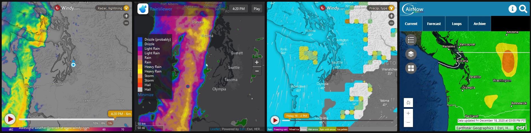
This integration is officially dead. NWS changed their servers, and the new API will likely require a whole new integration.
These are good alternatives:
RainViewer
Windy
I use both and both are embedded into an iframe in HA. I also embed an AirNow air quaility map.
type: iframe
url: >-
  https://embed.windy.com/embed2.html?lat=47.492&lon=-122.528&detailLat=47.536&detailLon=-122.278&width=650&height=450&zoom=7&level=surface&overlay=radar&product=radar&menu=&message=true&marker=&calendar=now&pressure=&type=map&location=coordinates&detail=&metricWind=mph&metricTemp=%C2%B0F&radarRange=-1
aspect_ratio: 100%
type: iframe
url: >-
  https://www.rainviewer.com/map.html?loc=47.6248,-123.6566,7&oFa=0&oC=0&oU=0&oCS=1&oF=0&oAP=0&rmt=2&c=2&o=83&lm=0&th=1&sm=1&sn=1
aspect_ratio: 100%
type: iframe
aspect_ratio: 100%
url: >-
  https://embed.windy.com/embed2.html?lat=47.492&lon=-122.528&detailLat=47.536&detailLon=-122.278&width=650&height=450&zoom=7&level=surface&overlay=ptype&product=ecmwf&menu=&message=true&marker=&calendar=now&pressure=&type=map&location=coordinates&detail=&metricWind=mph&metricTemp=%C2%B0F&radarRange=-1
type: iframe
url: >-
  https://gispub.epa.gov/airnow/?xmin=-14401959.121379772&ymin=5554831.71954033&xmax=-12914800.29906338&ymax=6496535.9080137005&clayer=ozonepm&mlayer=2.5
aspect_ratio: 100%
Got them all up and running replacing the NWS section.
On the Airflow how did you determine the coordinates to use?
Thanks
Need some help, removed the old HACS integration, the camera config and the card that used the image. There are no integration config files in /config/custom_components or /config/custom_components/hacs for nwsradar. I am getting this error at boot and the system pops an notification.
ERROR (MainThread) [homeassistant.setup] Setup failed for nwsradar: Integration not found.
The ha db does show it uninstalled as well.
home-assistant_v2.db:hacs/repository{"id": 1337, "action": "uninstall", "repository": "MatthewFlamm/nwsradar"}LOCAL2020-12-20 18:47:34.9766972020-12-20 18:47:34.9766975ff11610ddc41b559e8521039b00fc7cr
Also have this db entry as well.
home-assistant_v2.db:call_service{"domain": "persistent_notification", "service": "create", "service_data": {"title": "Invalid config", "message": "The following integrations and platforms could not be set up:\n\n - nwsradar\n\nPlease check your config and [logs](/config/logs).", "notification_id": "invalid_config"}}LOCAL2020-12-20 18:55:35.3366682020-12-20 18:55:35.33666879894548b4844210118b0adb325190a8jg
You need to delete the integration from the homeassistant menu
Configuration >> Integrations
Thanks, did not even think to look there since this is a HACS integration. Now to find a replacement.
If you mean the AirNow, the location is in ‘Meter Coordinate System’. So the min and max determine your zoom level also. The easiest way is to just play with the numbers until you get the area and zoom that you want. It has been awhile since I set it up, but I was able to pull the meter system from Google Maps but I don’t remember how I did it.
You can also go into the page, hit Developer Tools in Chrome, then type in ‘map.extent’ to the console - will give you the current extents of where you are looking.
This page will help you more easily set up the windy.com embeds:
https://www.windy.com/-Embed-widget-on-page/widgets?47.000,-122.000,5
I just thought of this and this is how I set up my windy.com embeds; and I have added more:
I am currently revamping most of my pages and always looking for more.