On mine it GIF of the radar
No point in displaying a static image.
OP still functional.
It’s an animated gif that seems to update fairly regularly.
I didn’t notice any change in the image while loaded in HASS.
The setup from the original post still work.
Is anyone able to get this Dark Sky / forcast.io Widget into Home Assistant? I’m trying via camera component, but am only getting “Image not available”:
Info (Dark Sky blog post):
https://blog.darksky.net/forecast-embeds/
Example:
http://forecast.io/embed/#lat=51.801822&lon=9.667969&name=Somewhere&color=#00aaff&units=ca
Thanks!
Since it is a webpage and not an image, you will have to use panel_iframe.
panel_iframe:
  darksky:
    title: 'DarkSky'
    url: 'http://forecast.io/embed/#lat=51.801822&lon=9.667969&name=Somewhere&color=#00aaff&units=ca'
2 Likes
As @arsaboo suggested I use something like this in panel_iframe
ex:
panel_iframe:
  windy:
    title: 'Windy'
    icon: mdi:weather-windy
    url: !secret windy_url
  darksky:
    title: 'Darksky'
    icon: mdi:weather-lightning-rainy
    url: !secret darksky_url

2 Likes
Found a fix for Wunderground radar.
Go here: https://www.wunderground.com/weather-radar/
At the bottom right of the radar is an “Image Link”
Click the link to get the URL to the gif to be used in the still_image_url: field.
Cheers!
1 Like
How can i force an update of the image every 5 minutes?
i tried using scan_interval, but it doesnt result in an update
- name: Weather
platform: generic
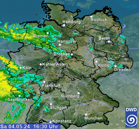
still_image_url: http://www.wettergefahren.de/DWD/wetter/radar/Radarfilm_WEB_DL.gif
scan_interval: 300
I use the generic camera component
Environment Canada makes the individual GIFs available as described at http://dd.weatheroffice.ec.gc.ca/radar/doc/README_radar.txt.
Below is a config item that I put together to fetch (nearly) the latest image from the radar near Ottawa, which is refreshed every 10 minutes:
camera:
  - platform: generic
    name: Franktown Radar
    still_image_url: http://dd.weatheroffice.ec.gc.ca/radar/PRECIPET/GIF/XFT/{{(as_timestamp(now()) - 600) | timestamp_custom('%Y%m%d%H%M', False) | regex_replace(find='(?<=\d{11})\d', replace='0')}}_XFT_PRECIPET_RAIN.gif
    content_type: image/gif
    limit_refetch_to_url_change: true
Here’s how the image URL is constructed:
- Base path:
http://dd.weatheroffice.ec.gc.ca/radar/PRECIPET/GIF/ - Station code:
XFT(available from the station URLs at https://weather.gc.ca/radar/index_e.html) - Timestamp of 10 minutes (600 seconds) ago:
(as_timestamp(now()) - 600) - Format timestamp to string in UTC:
| timestamp_custom('%Y%m%d%H%M', False) - Replace the 12th digit with 0, to align with the 10-minute period:
| regex_replace(find='(?<=\d{11})\d', replace='0') - Station again:
_XFT_ - End of filename:
PRECIPET_RAIN.gif
And here’s the output:

3 Likes
For the Netherlands you can use a Buienradar gif which you can find here. You can easily change the size by editing the w=480 and h=480 values
camera:
  platform: generic
  name: Weer
  still_image_url: https://api.buienradar.nl/image/1.0/RadarMapNL?w=480&h=480
content_type: 'image/gif'Here is a great resource for getting more radars
https://www.rainviewer.com/sources.html
maybe someone can make a real component out of this
1 Like
What about if I have a sequence of static images as:
https://geosite.climatempo.com.br/geoserver/wms?service=WMS&version=1.1.0&request=GetMap&layers=satelite:goesr_ret_ch13_ircol3_1,localidades:estados,localidades:paises&styles=,poligono_vazado_preto_fino,poligono_vazado_preto_fino&bbox=-9304526.579097936,-4079902.8217495675,-3072157.0408378043,812066.9885017126&width=636&height=477&srs=EPSG:3857&format=image/jpeg&transparent=true
Where the following part of URL is changed from 1 to 20.
…ircol3_1…
…ircol3_2…
…ircol3_3…
Till
…ircol3_20…
So, how can I have a moving image from the sequence of above static images?
It seems that as of 02:00 UTC (Oct 19, 2018) Environment Canada has stopped publishing the _XFT_PRECIPET_RAIN.gif image.
You will need to update the _XFT_PRECIPET_RAIN.gif to _XFT_COMP_PRECIPET_RAIN.gif
Hopefully this is a temporary thing but if not.
It’s temporary, they fail over to COMP (short for composite) images when a particular radar site is down.
Hagensieker, how did you get that Weather map on your card? Is is animated?
Is there a way to animate the image that’s grabbed using this method? All I’ve got is a still when I use this technique. Also, I’ve noticed that if I change the link from _WKR_PRECIPET_SNOW.gif to _WKR_COMP_PRECIPET_SNOW.gif I get a little more detail, but it also shows the circles for radar range; do you know a file naming convention or other way to choose which ovelays are included on the image? Ideally I’d like to find a way to imbed the 10-frame animate image with the city names and roads overlay enabled.
I’ve created a camera component that returns an animated image, the details are at this thread:
The COMP image is a fall-back that is used when the actual site requested is not available. It uses surrounding radars (where available) to try to build a composite image that covers the target area.
I haven’t figured out a way to add the overlays; they don’t seem to publish them.
Let me know if you have any more questions.