Hi! thank you for this code!
This solution shows me only the last strike and i wanna see the last 24 or 12 or anything else hours on the map. Do you have any idea?
For those still interested. By default, all Blitzortung strikes are shown on the large map view in Home Assistant. But you could also create a map card in one of your custom views.
The default zoom works for me, since I configured the integration with a 30km range.
If you don’t see any strikes, check the ‘source’ by looking at the attributes of one of the sensor.geo_ entities.
aware this is an older post, but you seem to be the only one doing what I was looking for
Ive been playing with those interactive cards, but havent found a way to make them zoom in on my region correctly. could you please show how you did that?
I struggled with getting rid of the cookie dialog in iframe as well and was never successful, so went a route that uses external web scrape to accept the cookies and then capture an image of the map. Kind of hillbilly tech, however it has been working without issues for months. Perhaps this code will give you some ideas. Good hunting!
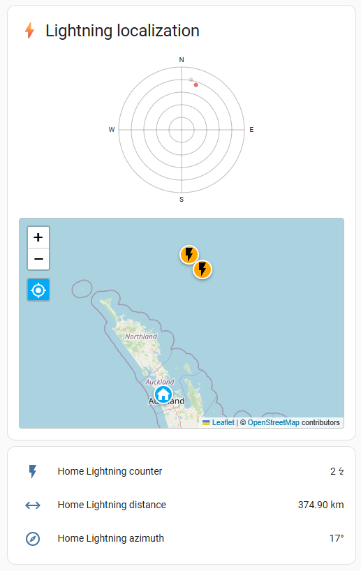
I recently published version 1.3.1 of my custom Lovelace card for visualizing Blitzortung lightning data in Home Assistant. I wanted to share it here because it now includes built‑in support for mapping lightning strikes, which fits nicely with this thread’s focus
What it does
This Lovelace card combines key lightning data from the Blitzortung integration into one clear dashboard. It supports:
Strike count
Distance to the nearest strike
Direction via real‑time compass
A fading radar chart of recent strike directions
A history chart of strike activity over time
An optional interactive map view displaying recent strikes relative to your zone.home (requires geo_location.lightning_strike_* entities)
Map View Features
Toggleable via show_map: true
Plots strikes over the same timeframe as the radar chart
Auto‑zoom initially to include all strikes; supports manual pan/zoom with a recenter button
Animated markers indicate new strikes
Respects your card theme with map_theme_mode (light/dark/auto)
Installation (via HACS)
Open HACS → Frontend → Explore & Add Repositories
Search for “Blitzortung Lightning Card” and install it
Add the card to your Lovelace dashboard using the visual editor
Enable geo_location entities in the Blitzortung integration options for map support
This thread is all about displaying lightning on a map — the map view is now a built‑in feature of this card, making it easy to see recent strikes at a glance, track their locations, and interact with them directly in your dashboard.
Always happy to hear feedback or feature ideas — let me know how it works with your setup!
Went down the rabbit hole the last two days, found it this Blue print on the Reddit, it sends a notification to the HA mobile App with a Map of lightning strikes. created by @zacharyd3
I use this with the Lovelace card from @timmaurice
can you explain the top 2 ‘radar’ like images?
Asking because I just use an auto-entities to show the strikes on the map if nearer than 25 km, so I wouldn’t need your CCard for that.
The 2 radar images seem rather cool though, Id love to check what you did there